


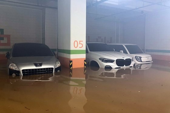
A part of the parking lot of an apartment in Wando-eup, Wando-gun, Jeonnam, is flooded with muddy water due to heavy rain on the morning of the 16th along the southern coast. Photo by Jeonnam Wando Fire Department
On the 16th, following the record-breaking heavy rain in the southern region, it is expected that very heavy rain equivalent to thunderstorms of up to 70㎜ per hour will fall twice on the Seoul metropolitan area on the 17th. It is necessary to be prepared for flood damage for the next ten days as the stationary front (monsoon front) is expected to linger over the central region, leading to concentrated heavy rain in the Seoul metropolitan area.
According to the Korea Meteorological Administration, on the 16th, heavy rain poured down mainly in the southern region due to the influence of rain clouds developing along the stationary front. At one point, Namhae-gun in Gyeongsangnam-do recorded an hourly rainfall of up to 74.9㎜. Consequently, a heavy rain warning was issued for Jeonnam and Gyeongnam coastal areas.
Earlier, in the early morning, some areas in Jeonnam experienced record-breaking rainfall exceeding 100㎜ per hour, resulting in flooding and other rain-related damages. Eoshin-myeon in Jindo, Jeonnam, recorded a rainfall of 103.5㎜ per hour. The Korea Meteorological Administration analyzed this as a rare occurrence of heavy rain that can happen once in 200 years.
From the night onwards, the rain expanded to the central region, bringing heavy rain to Chungcheong and the Seoul metropolitan areas. The Korea Meteorological Administration stated that “a strong rain cloud brought by the development of a stationary front over the West Sea is causing very heavy rain in the Chungcheong region.” They urged everyone to be especially cautious to prevent any flood damage.

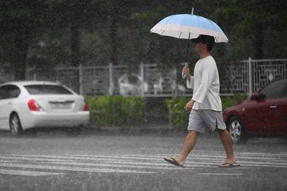
A citizen walking with an umbrella in front of Gwangju Seo Police Station in Gwangju Seo-gu on the morning of the 16th. Yonhap News
On the 17th, as the stationary front moves northward, heavy rain is forecasted to concentrate in the Seoul metropolitan area. Especially from early morning until late at night, heavy rain equivalent to thunderstorms is expected to pour down twice. Northern Gyeonggi Province is expected to receive very heavy rainfall of over 70㎜ per hour, while the rest of the Seoul metropolitan area, including Seoul, will experience rainfall of 30-60㎜ per hour.
공상민, a weather analyst at the Korea Meteorological Administration, stated that “on the morning and afternoon of the 17th, as the precipitation associated with the front of a low-pressure system moves away and the stationary front reactivates strongly towards Gyeonggi Province, severe rain is expected.” He also explained that “from the night of the 17th to the morning of the 18th, the stationary front will compress, bringing another round of heavy rainfall centered on the Seoul metropolitan area.”
Overnight on the 17th, as the stationary front compresses, a long and narrow rainy belt east-west and narrow north-south may form, concentrating very heavy rain where rain clouds stay. The expected precipitation until the 18th is 80-120mm in the Seoul metropolitan area and other regions, with some areas receiving more than 150mm of heavy rainfall. Northern Gyeonggi Province could record a cumulative rainfall of over 250mm. Gangwon Province is expected to receive 50-100mm of rain, and Chungcheong Province is forecasted to get 30-100mm of rain.

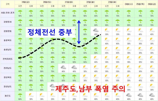
According to the mid-term forecast by the Korea Meteorological Administration, heavy rain is expected to continue in the central region, including the Seoul metropolitan area, until the 26th, while a heatwave is expected to expand in the southern region. Korea Meteorological Administration provided
In contrast, on the 17th, it is expected that most of the rain will subside as the southern region moves out of the influence of the stationary front. Instead, there is a forecast of scorching heat with the perceived temperature reaching up to 34 degrees Celsius. While heavy rain has been concentrated in the southern region so far, the weather is expected to reverse with heavy rain in the Seoul metropolitan area and a heatwave in the south.
This is due to the fact that as the rainy season nears its end in late July, the North Pacific High Pressure system positioned in the south of the Korean Peninsula is gradually moving northward, pushing the stationary front upwards. The stationary front is expected to continue to oscillate north and south over the central region, bringing heavy rain in the Seoul metropolitan area until the 26th. However, there is a high possibility that a heatwave advisory will be expanded in the southern region and Jeju Island.
우진규, a forecaster at the Korea Meteorological Administration, mentioned that “as we enter late July and reach the normal end of the rainy season, there is a tendency for the rainy cloud mass to dissipate in the southern region and Jeju Island.” He also stated, “Depending on whether the stationary front, along with the North Pacific High Pressure system, moves further south, we need to observe the situation to see if the rainy season will end.”