

When approaching an accident or disaster site, danger is communicated through voice guidance,
Photo=Provided by Naver,
, ‘Naver announced on the 17th that it has implemented a new update for Naver Maps that enhances the delivery of various accidents and disaster information on user-patrolled roads and strengthens disaster information guidance when using navigation.’,
,
, ‘Warnings include various incidents such as road control, construction, traffic accidents, and disasters that occur on the road. Naver Maps provides warning information based on the administrative district of the user’s registered home or company information or current location. It collects various information through local governments, various administrative agencies, real-time news, user reports, etc., and summarises it in card form so that users can check it in a timely manner.’,
,
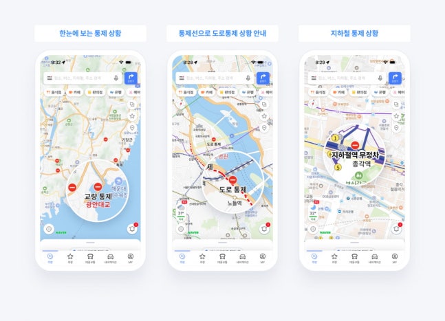
, ‘The card also includes information on traffic control situations on major roads and bridges due to accidents or disasters, as well as information on the suspension or delays of subway and train stations. Users can quickly check incident details and location information at a glance through information cards, and it is also possible to directly observe the situation on-site through the representative CCTV connected to the card. By selecting the card, users can move to a detailed page that provides detailed information about the incident. The detailed page provides a description of the incident, as well as the start and end times. In the case of a disaster incident, it provides a link to disaster action guidelines in Naver Knowledge Encyclopedia to help users respond.’,
,
Photo=Provided by Naver,
, ‘This update introduced features to Naver Maps that increased user convenience in moving within the past several months, including △public transportation route guidance service △iOS Live Activity feature that provides real-time public transportation route guidance without opening the app △avoidance route guidance for users who have difficulty using stairs △driving score functionality that analyzes user driving habits based on user driving records, and more.’,
,
, ‘According to Naver, as a result, the Naver Maps active users (MAU) for public transportation and navigation functions have continued to increase, leading to an overall increase in Naver Maps app MAU. Indeed, Naver Maps app MAU was confirmed to have increased by about 15% compared to last year.’,
,
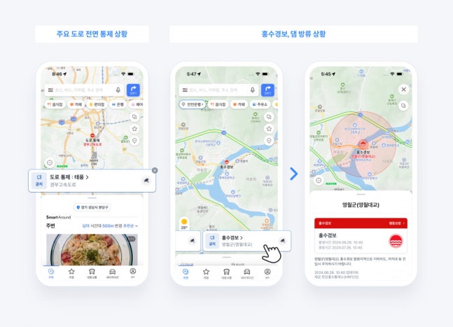
, ‘Naver Maps reorganized the warning information icons from the existing 4 types (traffic control, accidents, construction, others) to 7 types, including adding new disaster alerts for floods, dam discharge notices, and large-scale fires. The reorganized icons are emphasized on the map for users to check more intuitively and increase visibility. Also, the map now provides traffic control information for roads and subway stations as a default instead of having to activate the traffic information button on the existing Naver Maps. Control sections including bridges, tunnels, and underground passes are marked on the map with red dashed lines for users to easily check at a glance.’,
,
, ‘Additionally, to enable users to consider flood alerts and dam release news in their vehicle travel route plans, areas with flood alerts and dam release news are marked in advance on the route guidance line during navigation. Real-time information on sudden situations during driving is also delivered to users. Hazard information along the route is provided at the top of the mobile navigation screen, and incidents occurring nearby or adjacent to the incident point are also verbally guided.’,
,
, ‘Choi Seung-rak, Naver Maps Service Leader, stated, “As it is difficult to predict unexpected events that threaten the safety of pedestrians and drivers, the goal of this update is to enhance the deliverability of traffic safety information provided by Naver Maps in order to help users prevent accidents, drive safely, and manage their schedules efficiently” and said, “We plan to continue to further enhance Naver Maps as an ‘all-in-one platform’ that provides convenient and sophisticated travel experiences and supports users throughout their journey.”‘,
,
,