

Heatwave in Seoul for the Entire Month
Central Disaster and Safety Countermeasure Headquarters in Stage 1 Activation, Crisis Alert Level ‘Caution’
,
,
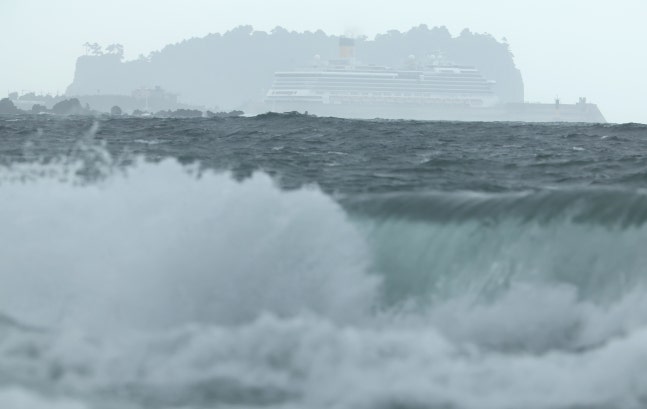
Typhoon No. 9 Jangdari is moving north on the morning of the 20th, strong waves are hitting the sea in front of Yeraedong in Seogwipo, Jeju. A large cruise ship anchored at Gangjung Port and Beom Island are visible behind the waves. /Yonhap News,
, ‘ Typhoon No. 9 ‘Jangdari’ is moving north and is expected to affect Jeju Island from the afternoon of the 20th. Jangdari is weak in strength but will bring strong rain and wind of up to 100 mm. The Ministry of the Interior and Safety activated Level 1 emergency response at the Central Disaster and Safety Countermeasure Headquarters at 8 a.m. on this day and raised the crisis alert level from ‘concern’ to ‘caution.”,
,
, ‘According to the Korea Meteorological Administration, Jangdari is expected to pass 180 km southwest of Seogwipo, Jeju at noon on this day and arrive at a point 90 km west of Seogwipo at 6 p.m. The central pressure is 998 hPa, maximum wind speed is 68 km/h, and the radius of strong winds is 150-180 km.’,
,
, ‘Jangdari is expected to transform into a weaker tropical low-pressure system (with a maximum wind speed of less than 17 m/s) around 80 km northwest of Mokpo at midnight on this day. Jangdari will then change direction to the northeast after passing 70 km southwest of Seosan, Chungcheongnam-do at 6 a.m. on the 21st, crossing through the central region, passing near Sokcho about 30 km west, and gradually dissipating.’,
,
, ‘Due to Jangdari’s influence, rain is expected nationwide for a while. From this afternoon to tonight, 30-50 mm of rain is expected hourly on Jeju, the southern coast of Jeollanam-do, and around Jirisan. From this afternoon, Jeju will experience strong winds reaching up to 70-110 km/h (maximum wind speeds of 20-30 m/s), so caution is advised for safety.’,
,
,
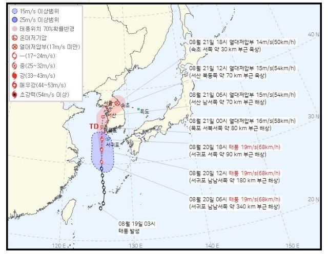
Typhoon No. 9 ‘Jangdari’ expected path. /Korea Meteorological Administration website capture,
, ‘ From today to the 21st, heavy rain of over 100 mm is expected in the mountains of Jeju, around the middle and outskirts of Jirisan, the western coast of Jeollabuk-do, and the southern coast of Jeollanam-do. Jeju, Busan, Ulsan, Gyeongsangnam-do, and Honam regions are expected to receive 30-80 mm of rain. In the Seoul metropolitan area, inland and mountainous areas of Gangwon, Daejeon, Sejong, and Chungcheongnam-do, 20-60 mm of rain is forecasted (over 80 mm in the southern part of Gyeonggi, the western coast of Chungcheongnam-do, Sejong, and inland northern Chungcheongnam-do), 10-60 mm in Chungcheongbuk-do, and 5-40 mm on the east coast of Gangwon. An approaching low-pressure system from the Shandong Peninsula of China will bring rain nationwide on the 22nd.’,
,
, ‘The relentless heat continues. Seoul has recorded 30 consecutive days of tropical nights (minimum temperatures above 25 degrees Celsius). According to the Korea Meteorological Administration, unless there is a significant change, Seoul’s minimum temperature will not drop below 25 degrees until the 30th. It is expected to break the all-time record for consecutive days above 25 degrees, set 117 years ago in 1907. Busan and Jeju are experiencing 26 and 36 consecutive days of tropical nights, respectively. The daytime high temperatures will range from 30 to 36 degrees.’,
,
,