33 consecutive nights of tropical nights…36 nights without sleep
Weekend heatwave continues, possibility of additional tropical nights ↑, ‘[Edaily reporter Lee Young-min] Despite scattered rain news over the weekend, the heatwave and tropical nights are expected to continue. Seoul, which has seen the most tropical nights since weather observations began in 1907, is expected to set a new record as the heatwave persists. ‘,
,
,
|
|
| A citizen under Banpo Bridge in Seoul is fanning a baby. (Photo=news1) |
|
,
,
, ‘ According to the Korea Meteorological Administration on the 23rd, Seoul has experienced tropical nights for the 33rd consecutive day from the 21st to the 22nd of last month. Adding the 3 days of previous tropical nights, this year’s total number of tropical nights is 36, setting a new record. The previous record was 36 days set in 1994, so although this year and 1994 have the same number of tropical nights, the latest record is considered higher, making this year the year with the most tropical nights. ‘,
,
, ‘With the continued heatwave over the weekend, the number of tropical nights this year could increase. The highest temperatures on the 24th and 25th are forecasted to be between 31-35 degrees and 29-34 degrees, respectively. The hot and dry air following the edge of the Tibetan high pressure system in the atmosphere above the Korean Peninsula, along with warm southwesterly winds and high sea surface temperatures, are exacerbating the heat. Due to the high humidity, the maximum heat index is expected to stay around 33 degrees, maintaining the heatwave in most areas. ‘,
,
, ‘Showers are forecasted in Gangwon Province and southern regions. On the 24th, showers of up to 40 mm are expected in various parts of Gangwon Province and the Gyeongsang region. From the next day, rain is expected in Jeju as well. In areas with rainfall, strong winds, thunder, and lightning may accompany the rain. Although the temperature may temporarily drop during the rain, it will rise again after the rain stops. ‘,
,
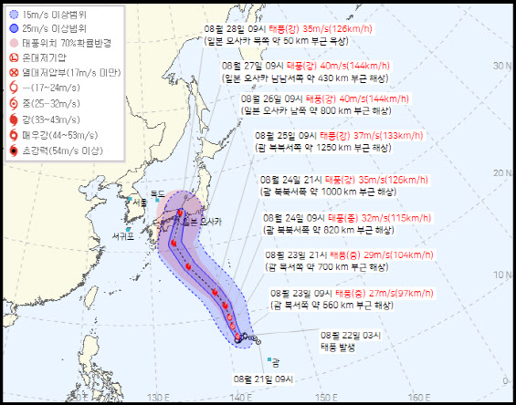
, ‘Meanwhile, the impact of Typhoon Shanshan on South Korea is expected to be minimal. As of 9 a.m. on this day, Typhoon Shanshan, moving towards Japan from the sea about 560 km northwest of Guam, is expected to strengthen to a maximum speed of 40 m/s by around 9 a.m. on the 27th and move north to the sea about 430 km northwest of Osaka, Japan. The Korea Meteorological Administration predicts that the typhoon, which will advance to the waters in front of Osaka, will change direction and move to land about 50 km north of Osaka by around 9 a.m. on the 28th, instead of the Korean Peninsula. ‘,
,
,
|
|
| Typhoon Shanshan is moving northbound from the vicinity of Guam towards Japan. (Photo=Korea Meteorological Administration) |
|
,
,
Visited 14 times, 1 visit(s) today